
RTR 1 : Radio propagation
What is Radio Propagation?
- Radio propagation refers to how radio signals (electro-magnetic waves) travel through space from a transmitting aerial to a receiving aerial. When an alternating current of suitably high frequency is fed to a transmitting aerial, its energy radiates out into space to create these radio waves. When a radio wave travels through the Earth’s atmosphere, we call it “propagation”.
- Example: Think of propagation like throwing a stone into a pond; the way the ripples travel outward through the water is similar to how radio waves travel through the air.
While modern technology has advanced, there are still only three basic methods (or waveforms) by which radio waves travel. Modern wireless technology still relies on three constant radio wave propagation methods—ground wave, sky wave, and space wave (or line-of-sight)—which exist across the entire electromagnetic spectrum (VLF to EHF).
All three methods of propagation (Ground, Sky, and Direct/Space) exist in all frequency ranges.
However, depending on the frequency, one method will always be highly effective while the others will be limited by physics or atmospheric conditions.
Frequency Bands and Propagation Methods
| Frequency Band | Range | Optimum Method of Propagation | Usable but Non-Preferred Methods (and Why) |
| VLF (Very Low Frequency) | 3 – 30 kHz | Ground Wave: Guided between the Earth and the ionosphere, traveling many hundreds of miles if transmitted with high power. Not preferred at mass scale at antenna length required will be too high. | Direct Wave is Limited to line-of-sight; impractical since VLF is meant for vast distances.Sky Wave: Not needed, as the ground wave naturally guides between the Earth and ionosphere anyway. |
| LF (Low Frequency) | 30 – 300 kHz | Ground Wave: Follows the Earth’s contour effectively. | Sky Wave: Suffers from heavy attenuation (weakening) by the D layer of the ionosphere during the daytime. |
| MF (Medium Frequency) | 300 – 3000 kHz | Ground Wave: The most effective user for maritime communications up to a few hundred miles. | Sky Wave: Can be used at night (via E layer refraction) when the sun’s D layer disappears. During the day, the D layer completely absorbs it, making it unreliable. |
| HF (High Frequency) | 3 – 30 MHz | Sky Wave: Refracts off the E and F layers of the ionosphere for long-range, over-the-horizon communication. | Ground Wave: Attenuates (loses power) very rapidly at these higher frequencies due to ground absorption.Direct Wave: Only good for short, line-of-sight distances, defeating the purpose of using HF for long-range comms. |
| VHF (Very High Frequency) | 30 – 300 MHz | Direct / Space Wave: Strictly Line-of-Sight; requires high antenna placement (like aircraft or ship masts). | Ground Wave: Extremely high attenuation; the signal is almost immediately absorbed at short range by the Earth’s surface and cannot follow its contour.Sky Wave: Frequencies are too high to be reflected by the ionosphere; they pass straight through into space. |
| UHF (Ultra-High Frequency) | 300 – 3000 MHz | Direct / Space Wave: Line-of-Sight communication. | Ground Wave & Sky Wave: Just like VHF, ground waves die immediately, and sky waves punch straight through the ionosphere into space. |
| SHF (Super High Frequency) | 3 – 30 GHz | Direct / Space Wave: Line-of-Sight communication. | Ground Wave & Sky Wave: Same limitations as VHF/UHF; strictly unusable for over-the-horizon propagation. |
1. Direct Wave & Space Wave (Line of Sight)
This method relies on the transmitting and receiving antennas being able to “see” each other in a straight line.
- Direct Wave: Travels in a straight line from one antenna to another. Because the Earth is curved, the “radio horizon” dictates how far the signal can go.
- Good News: Radio waves travel slightly further than visible light due to reflection and refraction, meaning the radio horizon is slightly further than the visual horizon.
- VHF (Very High Frequency) uses Direct Wave. This is why ships put their VHF antennas as high as possible—like at the top of a sailboat’s mast or above a ship’s bridge—to “see” further over the Earth’s curve.
- Space Wave: This is also “Line of Sight,” but because it involves aircraft or satellites high in the sky, the range is vastly improved.
- Systems that use this: VHF (DSC & RT), SART (Search and Rescue Transponder), AIS (Automatic Identification of Shipping), and EPIRBs.
- Limitation: For ground-to-ground (terrestrial) communication without satellites, this is limited to about 35 miles offshore.
2. Surface Wave ( non ionospheric)
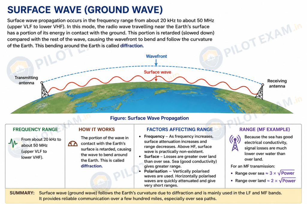
Instead of going in a straight line, these waves hug the Earth and travel along its surface.
- How it Works: They follow the contour of the Earth, bending over the horizon, which allows them to travel hundreds of miles if transmitted with enough power in the VLF (Very Low Frequency) and LF (Low Frequency) bands.
- The Catch (Attenuation): They are heavily influenced by the ground they travel over. Porous materials like sand or water absorb power from the wave, making the signal weaker. This weakening process is called Attenuation.
- Surface wave propagation can occur over a frequency range from approximately 20 kHz up to about 50 MHz, covering the upper part of the VLF band through to the lower VHF band.
- In this mode of propagation, the portion of the electromagnetic wave that remains in contact with the Earth’s surface experiences a slight reduction in speed. This causes the wavefront to bend and follow the curvature of the Earth, a phenomenon known as diffraction, enabling communication beyond the visual horizon.
- The effective range of a surface wave depends on several key factors, including the operating frequency, the nature of the surface over which it travels, and the polarization of the transmitted wave. As frequency increases, attenuation due to the Earth’s surface also increases, resulting in a reduced propagation range. Consequently, surface wave propagation becomes negligible at frequencies above the HF band.
- Surface characteristics play a significant role in signal strength. Conductive surfaces such as seawater support better propagation with lower attenuation, allowing signals to travel longer distances. In contrast, land surfaces—particularly those composed of dry or porous materials—absorb more energy from the wave, causing greater attenuation and limiting range.
- Polarization is another critical factor. Horizontally polarized waves experience rapid attenuation and are unsuitable for long-distance surface propagation. Therefore, vertically polarized waves are predominantly used in LF and MF bands, especially in maritime communication systems, where they provide reliable coverage over distances of several hundred miles.
- Surface waves are not the same as sky waves. Surface waves travel along the Earth, whereas sky waves rely on ionospheric reflection. Confusing these leads to incorrect understanding of long-range communication.
- As a practical rule of thumb, the maximum surface wave range over the sea is about 3 × √Power, whereas over land it is only about 2 × √Power. ( usable range will be limited till the first significant obstacle in the direction of propagation.)
Summary
3. Sky Wave
When you need to communicate thousands of miles away (far beyond the horizon), you can bounce your radio waves off the sky.
- The Ionosphere: This is a layer of the atmosphere between 50 and 400 miles above the Earth that acts like a mirror for radio waves.
- The Layers:
- D Layer: Created by the sun’s radiation, so it only exists during the day. It weakens (attenuates) radio signals.
- E Layer: Weakens the signal but also starts to bend (refract) it back towards Earth.
- F Layer (The Most Important): This is the main “reflector” for long-distance High Frequency (HF) communications. During a summer day, it splits into F1 (180 miles up) and F2 (250 miles up). At night, they combine at around 180 miles.
- Day vs. Night: At night, the D disappears and E layers go higher, meaning less signal is lost. This is why you can often hear faraway radio stations much clearer at night!
Important Sky Wave Terminology
- Skip Distance: The distance along the Earth’s surface from the transmitter to the exact point where the Sky Wave first returns to Earth.
- Skip Zone (Silent/Dead Zone): The dead area where no signal can be heard. It is the gap between where the Ground Wave dies out and where the first Sky Wave finally lands.
- LUF (Lowest Usable Frequency): The point at which a single Sky wave returns to Earth.
- MUF (Maximum Usable Frequency): The point where the wave loses too much power, becomes too weak, and won’t radiate properly.
- OWF (Optimum Working Frequency): The “sweet spot” for communication, ideally about 85% of the MUF.
- Sporadic-E Reflections: This is the specific term used to describe the weak sky waves produced in the Very High Frequency (VHF) band. These reflections occur when the atmosphere’s E-layer develops areas of very high ionization density
- Freak or Anomalous Propagation: This is the broader category of unusual atmospheric conditions—which includes scatter propagation and the resulting sky waves—that allows VHF radio signals to occasionally bypass their normal line-of-sight limitations and achieve much greater ranges.
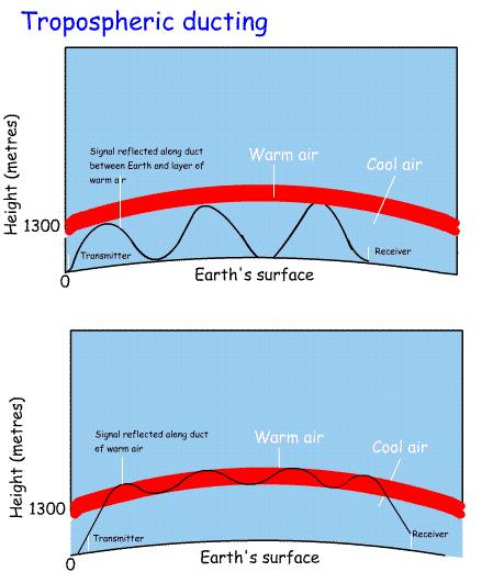
- Duct propagation (super-refraction): occurs in the lower troposphere under specific meteorological conditions, mainly a temperature inversion combined with a rapid decrease in humidity with height. These conditions create a refractive index gradient that bends VHF radio waves back toward the Earth, effectively trapping them in a “duct.” As a result, signals can follow the curvature of the Earth and propagate far beyond normal line-of-sight limits. This phenomenon is relatively stable compared to other anomalous modes and is commonly observed during high-pressure systems, especially at night or early morning, or when warm air overlies a colder surface such as the sea. In aviation, duct propagation may lead to extended reception ranges but can also introduce interference between stations operating on the same frequency and produce misleading echoes on radar displays.
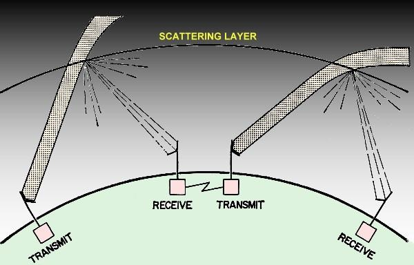
- Scatter propagation, on the other hand, originates in the upper atmosphere, particularly due to localized regions of intense ionization in the E-layer (commonly referred to as Sporadic-E). In this case, VHF signals are not trapped but are instead weakly reflected and scattered in random forward directions. The resulting propagation is highly irregular and unpredictable, often producing intermittent and fluctuating signal reception at distances well beyond normal range.
- Unlike duct propagation, it does not provide a stable communication path, making it unsuitable for reliable aviation use. However, it may occasionally allow extended-range contacts and can cause mutual interference between VHF communication and navigation aids.
What changes the Skip Distance?
- Frequency: Higher frequencies usually bounce off higher layers of the ionosphere, creating longer skip distances.
- Ionospheric Conditions: High ionization levels can create shorter skip distances.
- Angle of Radiation/transmission: If you point the antenna lower to the horizon, the wave travels further before hitting the ionosphere, resulting in a much longer skip distance.
Aviation Navigation & Communication Specifics
- VHF (117.975 – 137 MHz): The primary workhorse for short/medium-range voice communication between pilots and air traffic controllers.
- Data Links:While VHF voice is primary, data link systems like CPDLC (Controller Pilot Data Link Communications) and ADS-C (Automatic Dependent Surveillance Contract) are increasingly used for managing airspace, especially over oceanic areas. Examples: CPDLC and ADS-C are used by Mumbai, Chennai, and Kolkata OCCs.
- DCL and ACARS: Pre-Departure Clearances (PDC) in metro and major ATCCs like Bangalore and Hyderabad are enabled by Departure Clearance (DCL) and/or ACARS (Aircraft Communication Addressing and Reporting System).
- VOR (108.0 – 117.95 MHz): A navigation aid that gives directional guidance, but it relies on line-of-sight.
- DME (962 – 1213 MHz): Distance Measuring Equipment that tells the pilot how far they are from a ground station.
- GNSS: Satellite navigation like GPS and GAGAN.