
Results
Q1. You intend to overfly a mountain ridge at an altitude of 15000 ft AMSL. The average air temperature is 15°C lower than ISA, the sea level pressure 1003 hPa. Which altimeter indication (standard setting) is needed?
16170 ft
Q2. Q65. Satellites used in GNSS, orbit the earth:
Correct answer is – Once in twelve hours.
Q3. Q43. On an IFR (Instrument Flight Rules) navigation chart, a number 80 within a 1° quadrant of longitude and latitude represents:
Correct answer is – Minimum Safe Altitude (MSA) for that area is 8000 feet.
Q4. Q85. When static vent gets blocked in an unpressurized A/C, the right action is to:
Correct answer is – Break the glass of VSI.
Q5. Which of the following represents the minimum for V1? *
Correct answer is C – VMCG
Q6. Q38. When an aircraft has turned 270° with a constant altitude and bank, the pilot observes the following on a classic artificial horizon:
Correct answer is – Too much nose-up and bank too high.
Q7. On a Jeppesen chart the figures “FL80 2700a” are displayed below an airway. What does the “FL80” indicate?
Correct answer is D – b. Minimum Enroute Altitude
Q8. Q31. At V_MCG the aircraft must not deviate laterally more than:
Correct answer is – 30 feet, recovery must be within 30 feet as demostrated.
Q9. Q63. Pressure Altitude = 5000 feet, QNH = 1018.25 hPa. What is the Indicated Altitude?
Correct answer is – 5150 feet.
Q10. Q94. As per ICAO yard stick, DME Accuracy is?
Correct answer is – ± 0.25 NM plus 1.25% of the distance measured.
Q11. Q12. A turn indicator is built around a gyroscope with:
Correct answer is – 1 degrees of freedom.
Q12. Q9. Deviation is 4°E, Magnetic Heading 132°, Variation 24°W. Find Compass and True Headings.
Correct answer is – 128°(C), 108°(T)
Q13. Q23. When True North is East of Magnetic North, variation is:
Correct answer is – west.
Q14. Q22. The A/C is overhead DME at 36000ft, what will the DME read?
Correct answer is – 5.92 NMs
Q15. Q33. The phase difference between the reference and variable signals on QDM 050° (VAR 10°W) for a conventional VOR is:
Correct answer is – 230°
Q16. Q24. When turning from SW to SE at 45°N, the roll out should occur at:
Correct answer is – 115°
Q17. Q59. Lag error in servo assisted altimeter is virtually removed by:
Correct answer is – Electro-mechanical pick off device.
Q18. Q93. After flying for 1 hr 30 min at G/S 150 Kts on a/c is 15 nm off track. If the remaining time to destination is 45 min at a G/S of 180 kts. Find closing angle.
Correct answer is – 7°
Q19. Q28. The altimeter requires inputs from:
Correct answer is – static pressure only.
Q20. Q48. Any Parallel of Latitude is a:
Correct answer is – Rhumb Line.
Q21. Q78. Highest latitude at which sun will rise above the horizon everyday and set is:
Correct answer is – 66°
Q22. Q11. In a standard atmosphere and at the sea level, CAS is:
Correct answer is – same as TAS.
Q23. The minimum value of V2 (class A): *
Correct answer is B – Must not be less than 1.1Vmc or 1.2Vs
Q24. Q71. TODA is the total distance available for an aircraft to take off, including the length of runway:
Correct answer is – Plus any clearway beyond the runway.
Q25. Q75. Course (T) 120°, TAS 180 Kts, W/V 340°/50 Kts. Find Drift, Heading (T) and G/S.
10°S, 130°, 216 Kts.
correct answer
Q26. Given: Fuel flow 28 Imp Gal / HR, specific gravity 0.72, TAS 154 MPH. What is the specific range?
Correct answer is A – 1.46 NM air distance / kg
Q27. Q40. If QTE is 220°, variation 10°W, the phase difference between the reference and variable signals for a conventional VOR is:
Correct answer is – 230°
Q28. During the climb after takeoff, the altimeter setting is adjusted at the transition altitude. If the local QNH is 966 hPa, what will happen to the altimeter reading during the resetting procedure?
It will increase
Q29. Q8. On a Mercator chart scale at 30°N is 1:1000000. Calculate scale at 40°S.
Correct answer is – 884,552
Q30. Q92. On a map scale of 1 : 1 × 10^6. How many inches are represented by ground distance of 400 km?
Q31. Q45. ROC (Rate of Climb) in feet can be calculated using the following relationship:
Correct answer is – TAS (in feet per minute) × Sin(Flight Path Angle).
Q32. Q70. If the pulse width/length in a primary radar is 0.5 μ sec, the range resolution would be?
Correct answer is – 75 meters.
Q33. Q72. Descending with constant TAS in ISA conditions, CAS will ______ and Mach no. will ______.
Correct answer is – Increase; decrease.
Q34. Q103. VR cannot be lower than the:
Correct answer is – can not be lower than V1, ( and V1 can not be lower than VMCG ).
Q35. You plan to fly from A to B at a TAS of 230 kt, a GS of 255 kt and an initial cruising pressure altitude of 15000 ft. What should you complete Item 15 of the ICAO Flight Plan?
Correct answer is B – N0230 F150
Q36. Q19. The altimeter consists of one or several aneroid capsules located in a sealed casing. The pressures in the aneroid capsule and (i) casing (ii) are respectively:
Correct answer is – (i) vacuum (partial) (ii) static pressure.
Q37. Given: Dry operating mass = 38 000 kg maximum structural take-off mass = 72 000 Kg maximum landing mass = 65 000 kg maximum zero fuel mass = 61 000 kg Fuel burn = 8 000 kg Take-off Fuel = 10 300 kg The maximum allowed take-off mass and payload are respectively:
Correct answer is C – 71 300 kg and 23 000 kg
Q38. Q91. On 3°GP at 3 DME, ILS glide slope shows 2 dot fly up indications on 4 dot indicator. Approximately how many feet a/c is above/ below G/S (glide slope)?
106 feet below G/S.
Q39. Q41. The scale in Transverse Mercator is correct at
Correct answer is – Datum meridian and its anti-meridian.
Q40. Q26. An aft COG generally results in:
Correct answer is – lower fuel consumption and greater range.
Q41. Q57. First Segment for climb starts from the end of the takeoff distance____
Correct answer is – At a screen height of 35′ and a speed of V2.
Q42. Q88. When selected, ______ mode puts the aircraft at the ____ of the display and enables ______ radar display.
Correct answer is – Expanded ILS; Bottom; Weather.
Q43. Q17. An aircraft is accelerating in the Northern hemisphere heading West. Will a direct reading magnetic compass (1) over-read / under-read and (2) Indicate a turn to the north/ south?
Correct answer is – over-read (2) north. ( acceleration apprent turn to nearer pole, that is 270 to 300 , toward north )
Q44. Q81. Distance: 500 nautical miles between A and B. Departure Time A: 12:00 UTC. Arrival Time B at 29°29’N 000°00’E: 14:30 LMT. Find Ground Speed.
Correct answer is – 200 Kts.
Q45. Q20. Refer item 19 of the ICAO flight plan, endurance is:
Correct answer is – fuel endurance of the aircraft.
Q46. Q25. The purpose of a compass swing is to attempt to coincide the indications of:
Correct answer is – compass north and magnetic north.
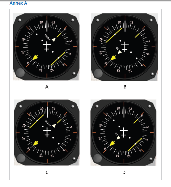
Q47. Using Annex A. An aircraft is flying on the 170 radials with a heading of 315°(M). The course on the HSI is set to 180°. Which HSI shows the correct indications?
Q48. Q46. A/c is tracking outbound from a VOR. The intention is to maintain the centreline of an airway which is defined by the 300° radial from the VOR. A back-bearing from the VOR shows the aircraft to be on the 295° radial, and at the same time the DME gives a range of 85nm from the VOR. Determine the aircraft’s displacement from the airway centreline.
Correct answer is – 7 nm
Q49. For a planned flight, the calculated fuel is as follows: Flight time: 3h 06min Reserve fuel, at any time, should not be less than 30% of the remaining trip fuel. Taxi fuel: 8 kg Block fuel: 118 kg How much fuel should remain after 2 hours flight time?
Correct answer is C – 30 kg trip fuel and 9 kg reserve fuel
Q50. Q90. A/C is approaching to stn on radial 300° with 10°S drift it is asked to approach on radial 270°. After reaching stn a/c is to hold on radial 110° non standard hold. What will be the type of entry?
Correct answer is – Parallel Entry.
Q51. Q1. Length of one NM is greater at ………………….
Correct answer is – At poles.1% more than equator. ( equator 1842.7, average 1852.3, Pole 1861.7)
Q52. Q100.Insert all clock times in the flight plan form in:
Correct answer is – 4 figures UTC (1505).
Q53. Q27. What do the upper and lower limits of the yellow arc on an ASI represent?
Correct answer is – VNE upper and VNO lower.
Q54. Q74. Radio Altimeter transmits:
Correct answer is – Frequency modulated continuous wave of frequency from 4200 MHZ to 4400 MHZ.
Q55. MCTOM- 45000 Kg MLM- 37000 kg DOM- 28000kg MZFM- 38000 kg Flight Time – 6hr Fuel Consumption – 1500 kg per hr Taxi- 600kg Reserve- 10% of Trip Fuel Diversion Fuel- 30 minutes Holding – 15 minutes Captain ordered to fill 12000kg fuel. Find Ramp fuel and the maximum traffic load that can be carried:
Correct answer is Fuel at Ramp*- 12000kg & Payload- 5600kg
Q56. Q64. Earth’s atmosphere causes signal delay as GNSS signals pass through it. The most prominent error responsible for delay is:
Q57. Q29. The blue line on an Airspeed Indicator (ASI) indicates ________ and is associated with:
Correct answer is – V_YSE, multi-engine aircraft.
Q58. Q14. Considering the MMO and VMO, the captain of a pressurized aircraft begins his descent from a high flight level. In order to meet his schedule time of arrival, he decides to use maximum ground speed at anytime of the descent, he will be limited by:
Correct answer is – Initially by MMO, then by VMO below a certain flight level.
Q59. Q15. A turn indicator is an instrument which indicates rate of turn. Rate of turn depends upon: 1. Bank angle. 2. Aeroplane speed. 3. Aeroplane weight. The combination of correct statements is:
Correct answer is – 1, 2
Q60. Q56. Dist = 2,400 nm, Trk = 080, W/V = 030/25 kts, TAS (N) = 440 kts TAS (R) = 360 kts, FOB = 10,000 kg, Reserve = 1,000 kg, FC (N) = 1,400 kg/hr, FC (R) = 1,000 kg/hr. Find DCP and TCP (aircraft returns on 3 engines from PNR).
Correct answer is –
Q61. Q35. To obtain a QDM it is necessary to add:
Correct answer is – The relative bearing of the station to the aircraft heading (M).
Q62. *For a large aircraft where the main and nose landing gears retract forward, the effect on the CG on lowering the gear is:
Correct answer is – to move aft
Q63. Q5. When the length of the day is measured with reference to the passage of the apparent sun:
Correct answer is – The length of the day will vary in the course of the year.
Q64. Q4. The periods of maximum rate of change between day and night is during:
Correct answer is – Equinoxes.
Q65. Minimum Fuel calculation: The trip fuel for a jet aeroplane to fly from the departure aerodrome to the destination aerodrome is 5,350 kg. Fuel consumption in holding mode is 6,000 kg/h. The quantity of fuel needed to carry out one go-around and land on the alternate airfield is 4,380 kg. The destination aerodrome has a single runway. What is the minimum quantity of fuel which should be on board?
Correct answer is A – 13,000 kg
Q66. Q82. Type of altimeter that directly measure the distance to the ground below the aircraft is known as:
Correct answer is – Radio Altimeter.
Q67. Q52. FL350, Mach number 0.80, OAT-55°C. Find TAS ?
Correct answer is –
Q68. Q34. QDM and QDR are measured in degrees, which take into account:
Correct answer is – The Earth’s magnetic field.
Q69. How is V2 affected if T/O flaps 20° is chosen instead of T/O flaps 10° ? *
Correct answer is C – V2 decreases if not restricted by VMCA
Q70. A revenue flight is to be made by a jet transport. The following are the aeroplane’s structural limits: – Maximum Ramp Mass: 69 900 kg Maximum Take Off Mass: 69 300 kg Maximum Landing Mass: 58 900 kg Maximum Zero Fuel Mass: 52 740 kg Dry Operating Mass: 34 930 kg Trip Fuel: 11 500 kg Taxi Fuel: 250 kg Contingency& final reserve fuel: 1 450 kg Alternate Fuel: 1 350 kg TakeOff and Landing mass are not performance limited. The maximum traffic load that can be carried is:
Correct answer is A – 17 810 kg
Q71. Q68. FL250, OAT -15°C, TAS 450 kt. Calculate the LSS and Mach No.
Q72. Q98. The use of high frequency in SHF band in airborne weather radars is essential to:
Correct answer is – Detect the larger water droplets.
Q73. Q69. Code with specific meaning “No Code Allotted / Exiting FIR” is:
Q74. Q77. TE 95°, DRIFT 4°S, HDG 090°. Find Track required and TMG.
Correct answer is – 085°, 094°
HDG is 090, the drift is 4S = track that you are actually flying is TMG = 094.
Q75. Q60. Dist = 800 nm, TRK = 330, W/V = 270°/30 kts, TAS = 240 kts, fuel on board 1,000 kg, F/C = 150 kg/hr, Reserve = 100 kg. Find DPNR and TPNR.
Correct answer is –
Q76. Q73. What is an Aclinic Line?
Correct answer is – Line joining zero magnetic dip.
Q77. Q18. A two-axis gyro measuring vertical changes will have:
Correct answer is – Two degrees of freedom and vertical axis.
Q78. Q76. Heading (T) 270°, TAS 250 Kts, Course (T) 267°, G/S 213 Kts. Find Drift and W/V.
Correct answer is – 3°P, 287°/39 Kts.
Q79. Q99. How much is the vertical coverage of the ILS Glide Slope?
Correct answer is – Up to 1.75° up and down to 0.45° above the horizontal.
Q80. Q62. If tail wind increases distance to CP will:
Correct answer is –
Q81. Q36. Density Altitude is:
Correct answer is – Pressure altitude corrected for variations from standard temperature.
Q82. You intend to overfly a mountain range. The recommended minimum flight altitude is, according to the aviation chart, 15000 FT/AMSL. The air mass that you will fly through is on average 15°C warmer than the standard atmosphere. The altimeter is set to QNH (1023 hPa). At what altimeter reading will you effectively be at the recommended minimum flight altitude?
14100 FT.
Q83. Q32. VOR station position N61° E025°, variation 13°E; Estimated position of an aircraft 59°N E025°, variation 20°W. What VOR radial is the aircraft on?
Correct answer is – 167
Q84. Q3. Aphelion occurs on approximately:
Correct answer is – 03 Jul
Q85. Q49. Lag error in VSI is removed by installing:
Correct answer is –
Q86. Q51. Seasons are caused due to:
Correct answer is – Inclination of the earth.
Q87. Q55. Dist = 1,500 nm, TAS (4 engines) = 360 kts, TAS (3 engines) = 300 kts, TRK = 090°, W/V = 330°/30 kts. Find DCP and TCP.
Correct answer is –
Q88. Q61. In order to convert true heading into magnetic heading a compass card and ______ are required?
Correct answer is – Map with isogonal lines.
Q89. Q83. The Cockpit Voice Recorder (CVR) and Flight Data Recorder (FDR) are designed to record the data for specific duration of:
2 hrs and 25 hrs.
Q90. Q53. On which projection is it impossible to indicate North Pole?
Correct answer is –
Q91. Q96. Frequency range of DME is:
Correct answer is – 960 to 1213 MHz.
Q92. Q42. An aircraft is required to approach a VOR station via the 244° radial. In order to obtain correct sense indications the deviation indicator should be set to:
Correct answer is – 064° with the TO flag showing.
Q93. Q97. An aircraft is on a VOR radial of 235° heading 003° (M), and with the OBS set to 060°. The correct indications are:
Correct answer is – TO; 1/2 scale deflection to the left.
Q94. Q66. Lines joining places of zero variation are called:
Correct answer is – Agonic lines.
Q95. Q67. Primary Radar (PSR) detection is based on ______. Secondary Radar (SSR) detection is based on ______.
Correct answer is – signal reflection (echo); transponder response.
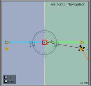
Q96. Given: Aircraft heading 150(M) Aircraft is on radial 100 from a VOR; Selected course on HSI is 090 The HSI indications are deviation bar?
Q97. Q37. Traffic Load/Pay Load consists of:
Correct answer is – The total mass of passengers, baggage and cargo, including any ‘non-revenue’ load.
Q98. Following departure from X with QNH 1005, the aircraft climbs to 10000’ and proceeds to Y. At Y, QNH is 997 hPa and QFE is 980 hPa. Determine the aircraft height above Y. Use 1 hPa = 30 feet.
Correct answer is – 9250
Q99. Q21. Circumference of the Earth is
Correct answer is – 40,000 KMs.
Q100. Q89. Rate one Turn at TAS 250 kts, the Bank angle is?
32
Q101. Q102. The blue line on an Airspeed Indicator (ASI) indicates
Correct answer is – V_YSE, speed providing maximum rate of climb with one engine becomes inoperative
Q102. Q87. The stopway surface must be capable of supporting the:
Correct answer is – Weight of the aircraft without causing structural damage.
Q103. Q44. What ROD is required to maintain on 3.5° GS at 150 Kts?
Correct answer is – 795 ft/min
Q104. Q39. A and B are on parallel of 30°S, longitude of A is 12°E, G/C brg of A from B is 266°. Find longitude of B.
Correct answer is – 28E
Q105. Q10. latitude nut in a Directional Gyro Indicator (DGI) is used to compensate for:
earth rate
Q106. Q79. Accuracy of one of the SSR Mode C is:
± 50 feet
Q107. Q30. V1 cannot be lower than the:
Correct answer is – V_MCG
Q108. Q6. An island is observed to be 15° to the left, A/C Hdg is 120°(M). Variation is 17°W, True bearing from A/C to the island is:
Correct answer is – 88
Q109. Q16. An airborne instrument, equipped with a gyro with 1 degree of freedom and a horizontal spin axis is:
Correct answer is – Turn indicator
Q110. Q13. Main cause of error in DRMC is:
Correct answer is – Turning error.
Q111. Q50. Calculate Total Fuel Required for a turbojet aircraft. Given: Thrust (F) = 80 kN, Specific Fuel Consumption (SFC) = 0.6 kg/(s.kN), Flight Time = one hour.
Correct answer is –
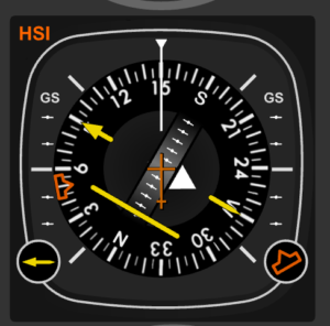
Q112. An aircraft is on the 120-degree radial from a VOR. Course 340 degrees is selected on the HSI (Horizontal Situation Indicator). If the magnetic heading is 070 degrees, the deviation bar relative to the aeroplane model will be?


Q113. In RNAV mode one dot on the EHSI represents:
Q114. Q2. The closest and furthest points of the Earth to the Sun are called:
Correct answer is – Perihelion and Aphelion.
Q115. Q54. Distance = 1,200 nm TRK = 090° TAS (Normal) 200 kts, TAS (Reduced) = 150 kts, Winds = 090°/20 kts. Find DCP and TCP.
Correct answer is – 680 nms: 3hrs 46mins.
Q116. Q80. When, in flight, the needle of a needle-and-ball indicator is on the left and the ball on the right, the aircraft is:
Turning left with too low bank.
Q117. Q58. The direct reading compass works on the principle that a magnetized compass card aligns itself with the:
Correct answer is – Horizontal component of the Earth’s magnetic field.
Q118. Q86. The width of a stopway shall not be less than the:
Correct answer is – Width of the runway it serves.
Q119. Q95. If the total number of persons is not known at the time of filing a flight plan, in Item 19 insert:
P/TBN (To be Notified).
Q120. Q101. A turn indicator is an instrument which indicates rate of turn. Rate of turn is independent of: 1. Bank angle. 2. Aeroplane speed. 3. Aeroplane weight. The combination of correct statements is:
Correct answer is – 3, independent of weight.