
Results
Q1. Nominal scale in Lambert conformal conic chart is correct at?
Correct answer is – Standard parallel
Q2. On a Mercator chart, the straight line (rhumb line) and the curved line (great circle) representing the path between two points exhibit:
Correct answer is – Chart convergence
Q3. In which of the following projections will the plane surface touch the radius of earth at one of the poles?
Correct answer is – Polar stereographic
Q4. On a Lamberts chart, the distance between parallels of latitude spaced the same number of degrees apart:
Correct answer is – Reduces between and expands outside the standard parallels.
Q5. On a polar stereographic chart, showing South pole, a straight line joining A-70°S 065E and B- 70°S025 W, the True course on departure from position A is?
Correct answer is – 225°(T). ( 180 + 45 )
Q6. # On a Lambert chart, with standard parallels at 37°N and 65°N, with respect to a straight line drawn on the map between A (49°N 030°W) and B(48°N 040°W), the:
Correct answer is – GC and rhumb line are to the south. ( answer is marked wrong in RK Bali )
Q7. Current flight plan is a flight plan which:
Correct answer is – includes changes brought about by subsequent clearances.
Q8. In column 15 of an ICAO flight plan, 250 knots cruising speed is written as:
Correct answer is – N0250 ( remember in 4 digit )
Q9. Radalt is dependant on:
Correct answer is – FMCW
Q10. Departure time entered in Item 13 of ICAO flight plan submitted before departure is:
Correct answer is – EOBT ( before departure EOBT, after takeoff clearance ATC updates the ETD )
Q11. Vmca is defined as the minimum speed, whilst in the air, that directional control can be maintained with one engine inoperative with:
Correct answer is – Max. of 5 degree bank ( When an engine, on a multi engine aircraft, fails or is inoperative in flight, the asymmetric thrust creates a yawing moment which causes the aircraft to turn towards the failed engine. Rudder is used to counteract this yaw and adverse roll effects are negated by use of the ailerons. There is a minimum speed at which, by using full rudder deflection, it is possible maintain a constant heading with level wings. This speed is reduced if the aircraft is banked towards the live engine(s). The speed that corresponds to full rudder deflection in combination with a 5 degree bank angle is defined, by regulations, as the minimum control speed and is referred to as Vmca (Velocity of Minimum Control in the Air). — Remember full rudder in case of VMCA, Full Rudder limited to 150lb force.
Q12. Maximum allowable take-off mass 64000 kg,Maximum landing mass 56200 kg,Maximum zero fuel mass 53000 kg,Dry operating mass 35500 kg,Traffic load 14500 kg,Trip fuel 4900 kg,Take-off fuel 7400 kg.Find maximum possible additional load:
Correct answer is – 3000 kg
Q13. Dry operating mass (DOM)- 33510 kgLoad- 7600 kgFinal reserve fuel- 983 kgAlternate fuel- 1100 kgContingency fuel 102 kgThe estimated landing mass at alternate should be:
Correct answer is – 42195 kg
Q14. A pitot tube covered by ice which blocks the ram air inlet, will affect the following instrument:
Correct answer is – ASI
Q15. In the ATS flight plan item 15 , when entering a route for which SID & STAR procedure exists:
Correct answer is – Both SID & STAR should be entered.
Q16. An NDB signal crossing from land to sea ______ in speed and bends ______ from the normal :
Q17. The still air distance in the climb is 189 Nautical Air Miles (NAM) and time 30 minutes. What ground distance would be covered in a 30 kt head wind?
Correct answer is – 174 nm
Q18. What is the operational limit for runway slope?
Correct answer is – +/- 2%
Q19. #Transverse Mercator charts are highly suitable for?
Correct answer is – Large N/S extensions ( wrongly marked in RK Bali )
Q20. which ICAO DOC is referred for FLIGHT PLAN?
Correct answer is – DOC 4444.
Q21. Doc 10085 is an?
Correct answer is – EDTO Manual
Q22. What determines the maximum and minimum range of a pulsed radar ?
Correct answer is – Pulse Repetition Time, Pulse Width.
Q23. Which error causes hunting in an ADF?
Static Interference and Precipitation 1st priority overnight effect.
Q24. GNSS maximum error is due to?
Correct answer is – Ionospheric Propagation Error
Q25. How does the forward CG affect the aircraft in terms of angle of attack, range, endurance ?
Correct answer is – Increased AOA , decreased range and endurance. ( corrected the question)
Q26. What is the indication of a VSI over a cold front ?
Correct answer is – a positive descend rate ( drop in static pressure )
Q27. Variation is not zero at a VOR , What do we follow on RMI ?
Correct answer is – Magnetic track. ( corrected the question)
Q28. Number of passengers not known, what has to be filled in flight plan Item 19?
Correct answer is – P/TBN(To Be Notified)
Q29. A/C MCTOM is 140000 kg, on the day it weighs 130000 kg, what should be entered in wake turbulence category?
Correct answer is – H
Q30. Fuel in an A/C is 14000 lbs, reserve fuel needed at landing is 2000lbs in a twin engine aircraft & fuel flow per engine is 1000 lbs/hr, TAS is 180 kts wind component (-)45 kts from dep to PNR ?
Correct answer is – 810 NM
Q31. More fundamental function causing Stall Warning is ?
Correct answer is – High AOA – excessive or critical Angle of Attack (AoA) – Modern stall warning systems are designed to detect the high angle of attack directly using sensors (like AoA vanes).
Q32. A/c at 24380 ft range 30 nm . What is the indicated range?
Correct answer is – 30.26 NM
Q33. Due to emergency the pilot descends at a greater rate he may expect:
Greater ground speed , long roll distance and undershooting of R/W. ( hits the ground early )
Q34. During the approach, a crew reads on the radio altimeter the value of 65 ft, this is an indication of true:
Correct answer is – Height of the lowest wheel with regard to ground at any time.
Q35. The altimeter consists of one or more several aneroid capsules located in sealed casing. The pressure in the aneroid capsule and casing are respectively:
Correct answer is – Vacuum(very low pressure or partial vacuum), Static.
Q36. The initial climb for a single-engine aircraft in the takeoff path typically involves:
Correct answer is – Vx followed by Vy ( first try to gain altitude follow Vx then switch to Vy for allowing acceleration.)
Q37. What does the turn coordinator indicate?
Yaw rate.
Q38. What is the true direction and distance (in NM) from point P, (48° 33’S, 57° 09 E) to point Q (71° 23′ S, 57° 09′ E)?
Correct answer is – 180°,1370 NM
Q39. You are flying a constant compass heading of 252°. Variation is 22°E, deviation 3°W and your INS is showing a drift of 9° right. True track is ?
280
Q40. Which band is RADALT operate in ?
Correct answer is – 4200-4400 Mhz
Q41. The failure of radio altimeter would?
increase the risk of CFIT. ( please remember Enhanced GPWS (EGPWS) are active and available during cruise, providing continuous protection against controlled flight into terrain (CFIT). While GPWS primarily modes (1-4) focus on low-altitude terrain closure and gear/flap configuration. EGPWS is not dependent of RADALT, utilizes GPS and terrain databases to provide forward-looking terrain avoidance (FLTA) during all flight phases, including high-altitude cruise. (NOTE: Also remember there is no such thing as HIGH ALTITUDE RADIO ALTIMETER, Military uses Phased Array Radars (like those on Aegis cruisers or Patriot missile systems) use phased array technology to scan vertically and horizontally simultaneously, providing precise height data of high flying object. )
Q42. What does the best angle of climb speed achieve?
Correct answer is – provides the maximum vertical climb without sacrificing too much forward progress.(remark – maximum rate of climb speed is higher than the best angle of climb speed )
Q43. The LMT and date at a longitude of 001°W is 1330 on 6th January, what is the LMT and date at longitude 159°E?
Correct answer is – 00:10 7th Jan
Q44. Aircraft is said to be “Neutrally stable” if the center of gravity is located at:
Correct answer is – aerodynamic center
Q45. ILS and GNSS are to be written in flight plan as:
Correct answer is – L, G
Q46. GPS (Global Positioning System) constellations are typically deployed in orbits that are inclined relative to:
Correct answer is – the Earth’s equator ( 55 degree)
Q47. Which of the following combination gives least performance:
Correct answer is – high humidity, high altitude, high temperature.
Q48. During a VFR flight at a navigation checkpoint the remaining usable fuel is 60 usg. The reserve fuel is 12 usg. According to the flight plan the remaining flight time is 1h 35mins. Calculate the highest average rate of consumption possible for the rest of the trip.
Correct answer is – 33.3 us gal/hr
Q49. The Operating mass of an aircraft is:
the dry operating mass plus the take off fuel mass.
Q50. The coded identification of the VOR is transmitted about every _____ seconds:
Correct answer is – 10 second interval ( in 30 sec hear 4 times, in 1 minutes 7 times )
Q51. An aircraft heading 140° (M) bears 320° (T) from a VOR (VAR 10° E). The bearing, selected on the OBS, which would make the VOR/ILS deviation indicator show TO would be:
Correct answer is – 130°
Q52. TCAS II (RA) provides the pilot with specific instructions on how to avoid the conflict with traffic by:
Correct answer is – quickly and steadily descending, climbing, or adjusting vertical speed.
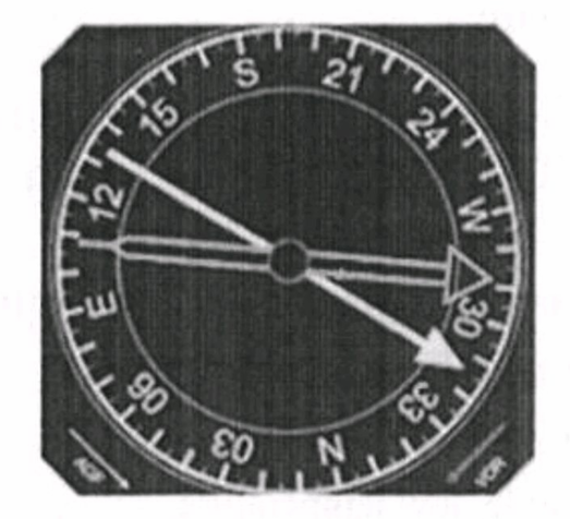
Q53. The indications on the RMI are shown below. Which of the following statements is correct? (Picture)
Correct answer is – Heading 192°M, VOR radial 132°M, NDB bearing 108°M.
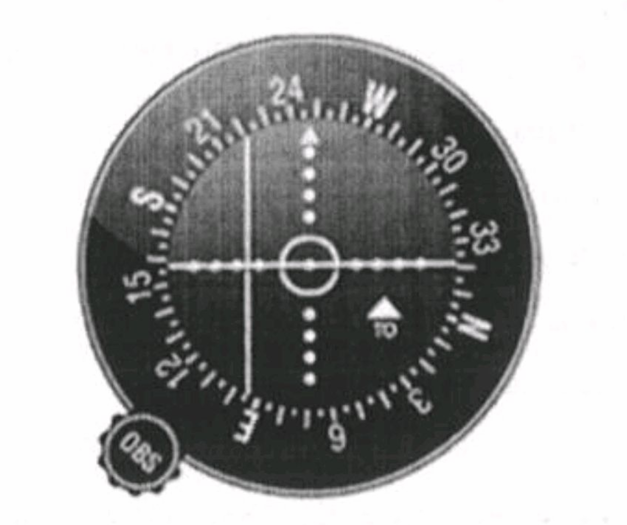
Q54. The aircraft is 60 nm inbound from the VOR.The ILS/VOR indicator below is set to define the centre line of an airway. The aircraft is located on which radial? What is the type of sensing and OBS selected? ( picture Q )
Correct answer is – 063°, normal,248°.
Q55. Unless otherwise stated on the charts for SID, the routes shown are given with:
Correct answer is – Mag Course
Q56. At night, a position has to be reported to ATC, distance 750 nm from ground station, what frequency is to be used?
Correct answer is – 5649 Khz ( we use HF, lower frequency in HF is prefered in night. do not memorise the answer), Higher than HF we do not use for RTF. ( only higher VHF and HF is used )
Q57. An aircraft flying an ILS is receiving an excess of 90 Hz modulation from both LOC and GP, what will be the fly indications on the CDI?
Correct answer is – Fly right and fly down
Q58. A multi engine aircraft is on IFR flight. Given the following data and assuming fuel consumption remains unchanged, which of the following statement is correct:Trip fuel: 65 USGContingency fuel: 5% of tripALT fuel including final reserve: 17 USGUsable fuel at time of departure: 93 USGAt point halfway to destination, fuel consumption is 40 USG
Correct answer is – Remaining fuel is insufficient to reach destination with reserves intact.
Q59. # What is the advantage of remote indicating compass over direct reading magnetic compass?
Correct answer is – It senses the earth’s magnetic field rather than it seeks, so it is more sensitive. ( It senses the magnetic meridian instead of seeking it, increasing compass sensitivity ) – wrongly marked in RK bali
Q60. An a/c on Hdg 340°M with ADF reading 190°, what will be the indication on RMI?
Pointer reads 340 + 190= 530= 170° & tail reads 350°
Q61. The period of validity of the navigational database is:
Correct answer is – 28 days
Q62. The FMC navigational database can be accessed by the pilots:
Correct answer is – to read information only. can add waypoint in between.
Q63. A landing compass:
Is used to establish aircraft magnetic heading during a compass swing.
Q64. What is Expected Approach Time (EAT):
Correct answer is – Estimated time to leave holding for landing following a delay.
Q65. An a/c plans to depart LONDON at 1000 UTC & arrive at Munich EDDM at 1215 UTC. In ATC flight plan item 16 should be entered:
Correct answer is – EDDM 0215
Q66. An aeroplane is flying from an airport to another. In cruise, the CAS is 150 kts, TAS is 180 kts, GS 210 kts, the ground speed box on the flight plan shall be filled as follows:
N0180
Q67. # Which of the following is not an advantage of a slotted antenna?
Directivity correct answer ( wrongly marked in RK bali )
Q68. A VOR and DME are co-located. You want to identify the DME by listening to the call sign. Having heard the same call sign 4 times in 30 seconds the:
DME call sign is the one with the higher pitch that was broadcast only once.
Q69. A radio altimeter can be defined as a:
Correct answer is – Self contained on board aid used to measure the true height of the aircraft.
Q70. #In Southern Hemisphere during landing in westerly direction , the magnetic compass will indicate:
Correct answer is – apparent turn to North – deceleration apparent turn to opposite pole ( wrongly marked in RK bali )
Q71. A pitot tube covered by ice which blocks the ram air inlet will affect the following instruments:
Correct answer is – Airspeed indicator only
Q72. Maximum allowable take-off mass 64400 kg; maximum landing mass 56200 kg; maximum zero fuel mass 53000 kg; dry operating mass 35500 kg; Load 14500 kg; estimated trip fuel 4900 kg; minimum take-off fuel 7400 kg. Find maximum additional load.
Correct answer is – 3000 kg
Q73. The ATC transponder system, excluding Mode S, contains:
Correct answer is – two modes A/C, each of 4096 codes.
Q74. The transponder code set in an SSR system consists of:
Correct answer is – 4 digits, forming any of 4096 different codes.
Q75. If the SSR transponder IDENT button is pressed an identification pulse is automatically and continuously transmitted for:
Correct answer is – 20 seconds, 4.35 μsec after the last framing pulse.
Q76. Distance from P to Q is 400 NM, with component +30 Kts, and wind component from Q to P is -40 Kts. All engines operative TAS is 160 Kts. The flight fuel is 2450 Kg and the Safe endurance is 4 hours. Calculate PNR for return to P. What is the distance from PNR to Q?
Correct answer is – 294 NM, 106 NM
Q77. The principal propagation path employed in an NDB/ADF system is:
Correct answer is – surface wave
Q78. An aircraft is flying straight and level, over a warm air mass. The altimeter reading will be:
Correct answer is – less than the real height
Q79. Minimum number of GNSS satellites required to carry out independent functions mentioned below is: 1. 3D operations, Receiver Autonomous Integrity Monitoring (RAIM) and to isolate any faulty satellite. 2. Operations to obtain a position. 3. 2D operations.
Correct answer is – 6,4,3
Q80. In a Doppler VOR (DVOR) the reference signal is ______, the bearing signal is ______, and the direction of rotation of the bearing signal is ______.
Correct answer is – AM, FM, anticlockwise.
Q81. Frequency and Wavelength of radio altimeter is?
Correct answer is – 4.2 GHz to 4.4 GHz and 7.14 cm to 6.82 cm.
Q82. An aircraft takes off from an airport 2 hours before sunset. The pilot flies a track of 090°(T). W/V 130/20 kts, TAS 100 kt. In order to return to the point of departure before sunset, the furthest distance which may be travelled is:
Correct answer is – 97 NM
Q83. An aircraft has a TAS of 300 knots and is over a stretch of water between 2 airfields 500 NM apart. If the wind component is 60 knots head, what is the distance from the first airfield to the critical point?
Q84. Preventive RA in TCAS II for no change in vertical speed required is:
Correct answer is – Monitor Vertical Speed
Q85. Purpose of latitude rider nut in DGI is to compensate for:
Correct answer is – earth rate compensation.
Q86. An NDB transmits a signal pattern in the horizontal plane which is:
Correct answer is – omnidirectional.
Q87. The middle marker of an ILS installation identifies itself with:
Correct answer is – dots and dashes with alternating an amber light.
Q88. An aircraft takes off from the aerodrome of ALPHA (altitude 1 483 ft, QFE = 963 hPa, temperature = 32°C). Five minutes later, passing 5,000 ft on QFE, the second altimeter set on 1013 hPa will indicate approximately:
Correct answer is – 6,400 ft
Q89. How do you measure your location using GPS?
Correct answer is – Simultaneous ranges from a number of satellites. ( range position line )
Q90. When descending through an isothermal level at a constant Mach number. The TAS will _______, the CAS ______ and the LSS will _______:
Q91. How many feet you have to climb to reach FL 75, departure aerodrome elevation = 1500ft, QNH = 1023 hpa, Temp = ISA, 1 hpa = 30 ft:
Q92. The time to reach the top level at a given gross mass is 36 minutes and the distance travelled is 157 NM (nil wind). What will be the distance travelled with an average tailwind component of 60 kts?
Correct answer is – 193 NM
Q93. Course 040°(T), TAS is 120 kt, Wind speed 30 kt. Maximum drift angle will be obtained for a wind direction of:
answer – 130 – when wind is coming form abeam (90 degree of the Tcrs then thedrift will be maximum.)
Q94. The hysteresis error of an altimeter varies substantially with the:
Correct answer is – time passed at a given altitude.
Q95. Distance from P to Q is 400 NM, wind component +30 Kts, and wind component from Q to P is – 40 Kts. All engines operative TAS is 160 Kts. The flight fuel is 2450 Kg and the Safe endurance is 4 hours. Calculate DCP and TCP between P and Q for reduced TAS of 130 Kts after one engine fails?
Q96. Typical Airborne Weather Radar (AWR) is gyro stabilised within limits in:
Correct answer is – pitch and roll.
Q97. The basic elements of the satellite navigation system NAVSTAR/GPS are:
Correct answer is – the space segment, the control segment and the user segment.
Q98. What is the purpose of the GPS control segment?
Correct answer is – To monitor the satellites in orbit.
Q99. If one out of 2 static port is not calibrated for position error, what will happen during high speed cruise?
At high speed, the non compensated altimeter will indicate a higher altitude. — ( wrongly marked in RK bali )
Q100. Common functions of Secondary Surveillance Radar (SSR) Mode S are:
Correct answer is – data linking, Improved ATC surveillance, reduced R/T communications and use by TCAS II.